Alan Roberts ; "When Three Shires Head Came to Pannier Pool"
Nowadays, Three Shires Head is a peaceful place. Set in the deep, narrow valley of the Dane, about four miles south west of Buxton, it is visited by families taking a picnic at Panniers Pool, with its ancient packhorse bridge, and walkers on the Dane Valley Walk.
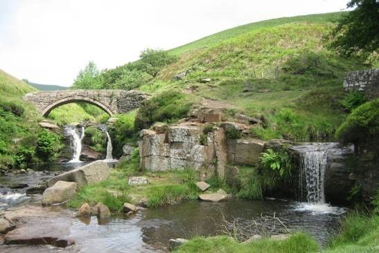
1) The packhorse bridge at Panniers Pool, Three Shires Head (location 8).
The Dane flows beneath the bridge; Raddlerake brook is on the right.
Four hundred years ago, it would have been a different scene, with packhorse trains passing through with coal from the local pits and slates from the local quarries. It was probably this trade in local minerals that gave rise to a long lived dispute as to the boundaries in this area, a dispute captured on a map of 1600. Also, at that time, the meeting place of the three shires - Cheshire, Derbyshire and Staffordshire - was somewhere else.
Following the dissolution of the monasteries, the 16th century was a time of development of large landed estates by private individuals and a growth in commerce and industry that resulted in a greater interest in the ownership of mineral rights. As a consequence of this, the exact boundaries of estates achieved a greater significance. Where, previously, boundaries had been agreed mainly by reference to natural features, more and more estate maps were produced to define boundaries more accurately and to resolve disputes between neighbouring estates. The 1600 map falls into this category. It is lodged at the National Archive, Kew (MPC 1/274) and the index entry records: "Two plans of lands in Hartington Derbyshire produced as evidence in a dispute between John Harpur, plaintiff, and Henry Cavendish and others, defendants."
The dispute rumbled on for more than 200 years and was not finally resolved until the Inclosure Award for the parish of Hartington in 1807. The report relating to the Award records that a boundary dispute had arisen between the parish of Hartington and the parish of Alstonefield. Sir Henry Harpur had lodged a claim and two Arbitrators (one from each parish) and a neutral umpire were appointed to resolve the dispute. The maps associated with this Award include one specifically related to this dispute, as a separate map was prepared for this area.
The main features of the 1807 map are shown on the accompanying sketch and the roads, rivers and county boundaries are essentially the same today. The disputed region lay between the Buxton to Congleton road (a Turnpike authorized by an Act of 1790, now the A54) and the Buxton to Leek road (a Turnpike authorised by an Act of 1765, now the A53) and to the south of a minor road across Axe Edge Moor, defined by the Inclosure Act. Further details of the area can be seen on the Ordnance Survey maps for the area. Details from the 1600 map are also given on the sketch. The numbers on the sketch identify locations referred to on the two maps and the key to the sketch gives the corresponding name or description.
Historically, the boundary between Derbyshire and Staffordshire had followed the River Dove to a source at Dove Head while the eastern boundary of Cheshire had followed the River Dane and the River Goyt in this area, with a short length across moorland between those two rivers. The dispute was based on the cross country link between the Dove and the Dane, specifically where this link joined the Dane.
As defined by the Inclosure Award, the boundary between the parishes of Hartington and Alstonefield (hence between Derbyshire and Staffordshire) ran from the River Dove at 1 to 5 on the sketch, in a mainly northerly direction, from 5 to 8 in a south westerly direction and then from 8 to 10 in a northerly direction along the River Dane, giving rise to the curiously zigzag route of the county boundary.
In the opposing claims, the parish of Hartington claimed a boundary running from 1 on the River Dove in a mainly westerly direction to Panniers Pool at 8 on the River Dane, via points 14, 15, 16 and 7 (along the more northerly of the two lines between 14 and 15), while the parish of Alstonefield claimed a boundary running from 3 to 5 via 18 and 19 and then from 5 to 8 via 6 and 7. In that respect, the Arbitrators awarded more of that disputed area to the parish of Alstonefield by the boundary that they fixed.
However, in the 1600 map, the dispute involved a larger area. At that time, the parish of Hartington claimed a boundary running from 3 to 14, along the southern route between 14 and 15 and then on to16, 7 and 8, whereas the accepted county boundary shown on that map ran from 1 to 5, via 2, 3 and 4 but then it took a shorter route to the River Dane at 9, via 11 and 12. The area between these two boundaries was labelled (in modern spelling) "parcel of Quarnford pasture that Hartington men make claim unto".
This boundary took a short cross country route from Cheeks Hill to the source of "Dirtie Clough" and followed this clough to the main stream of the Dane between what is now called Dane Head, at 13, and the junction of the Dane with Tinkers Pit Gutter at 9 (referred to as "a rindle coming to Dane" in the 1600 map). So, at that time, the meeting point of the three shires was at 9, as recorded on the 1600 map and the Derbyshire boundary ran in a more or less north westerly direction between Dove Head and Tinkers Pit Gutter.
The disputed area was about twice the size in 1600 to what it was in 1807, suggesting that there was a settlement in part of the 1600 dispute, with Alstonefield parish accepting the boundary from 5 to 8 in 1807.
As to the origins of the dispute, the 1600 map was clearly linked to the mineral resources of the area. Virtually all of the written material on the map, summarised in the key to the sketch, relates to minerals - "cole", "slates", "fyerston" and "redly", translating as coal, slates, firestone and raddle. The word "raddle" is carried through on to the 1807 map as well, in the form of "Raddle Rake Brook". " Firestone" is a heat resistant stone used in furnace linings or a stone used for striking fire, as pyrites or flint. "Redly" (or raddle/reddle/ruddle) is a variety of red ochre used for marking sheep. "Lach", as in "Redly lach", is a stream. "Redly Lach" survives as a name in "Readyleech Green"
Today, 200 years on from the final determination of the boundaries, the scene is peaceful. Mineral working has ceased, leaving traces behind, particularly in the abandoned Reeve Edge and Danebower quarries and the colliery workings near the Buxton to Congleton road but nature is steadily reclaiming the area and giving a weathered, lichen-covered charm to the remains. It was hardly an epic boundary dispute on a national scale but just one example of the mosaic of pieces that make up the British landscape.
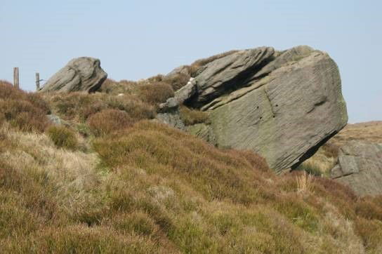
The Great Rock on Drystone Edge (location 4)
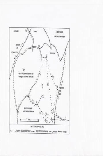
Key to locations marked on sketch:
Details taken from the 1600 or 1807 maps as indicated or from modern maps
1-2 River Dove
2 Dove Springe and Ryver head (1600); Dove Head
3 Eliot Ston on Ax Edge (1600); Axe Edge End
4 The great ston on Tristors Edge (1600); Great Rock, Droyster Edge (1807); Drystone Edge
5 The sett ston on the moss short of Dirtie Clough (1600); Cheeks Hill (1807)
6 Staden Hole (1807)
6-7 Glendale Hollow (1807)
7-8 Raddlerake Brook (1807)
6-7-8 Fyerston Bruck (1600)
7 Duke of Devonshire's Inclosures called Blackclough (1807); Blackclough
8 Panyers poole (1600); Threeshire Head or Panniers Pool (1807), Galleywood Bridge (1807)
8-9-13 The Ryver of Dane (1600); River Dane
9 The head of the Ryver of Dane where three shires meet (1600);
9-10 A rindle coming to Dane (1600); Tinkerspit Gutter
11-12 Dirtie Clough (1600)
13 Dane Head
3-14 minor road
14 Hilltop
14-15 The waye to the cole pitts (1600); minor road from Hilltop to Readyleech Green
14-15 1807 disputed boundary, across fields
15 Redly lach (1600)
16 Readyleech Green
15-16 Redly rakes waye (1600)
16-17 Blacke clough (1600)
16-7 Colpitt Bruck (1600);
18 Unmarked location, Axe Edge (1807)
19 A prominent group of rocks on Droyster Edge (1807)
20 Ryve Edge whear slates are gotten (1600); Reeve Edge (1807); Reeve-edge Quarries
21 Coles gott here (1600)
22 Coles gott here (1600)